
 2017-2019 Orange-Sullivan-Ulster Counties Update Imagery
The 2019 Spring flying season with leaf off conditions is over. This does not mean that we cannot help you if you have a project which needs our Photogrammetric Mapping services.
We are constantly updating our extensive library with high resolution imagery and have completed another update section of our existing 2005 imagery in Orange and Ulster Counties. This Digital Imagery flown at ¼’ pixel resolution is suitable for Photogrammetric mapping at a scale as large as 1” =40’ with 2’ contours, Digital Ortho Imagery, GIS Base Mapping, Accident and Real Estate Analysis. Outside the limits shown below we have 2004 thru 2006 imagery covering Columbia, Dutchess, Greene, Orange, Sullivan and Ulster Counties. 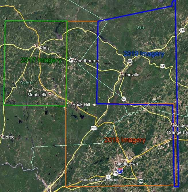
Our Connecticut Library Imagery was flown in 2001 thru 2004, 2012 and 2016.
If there is anything we can help you with regarding proposals or project planning, please let us know.
GOLDEN AERIAL SURVEYS
203-426-3322 (Phone)
203-426-3322 (Fax)
maps@goldenaerialsurveys.com
Golden Aerial Surveys, Inc. has been an active supporter of CALS and NYSAPLS for over 30 years.